

Construction permitting is a critical step in shaping the urban landscape, ensuring that proposed developments comply with zoning laws, building codes, safety standards, and environmental requirements. However, in many rapidly growing metropolitan areas, the permitting process remains slow, paper-heavy, and fragmented across multiple regulatory agencies. Developers frequently face long review cycles and limited transparency, while approval authorities struggle with incomplete or inconsistent technical submissions.
With modern urban environments growing increasingly complex, modernizing development oversight is essential. Integrating Building Information Modeling (BIM) and Geographic Information Systems (GIS) provides a path forward: shifting permitting from a disjointed administrative bottleneck into an automated, accurate, and transparent digital workflow, they can redefine how permitting is conducted, making it faster, more accurate, and more transparent.
BIM and GIS: Complementary Technologies
Individually, BIM and GIS operate at entirely different scales. Together, they provide a continuous digital thread between individual assets and the surrounding territory.
BIM (Building Scale): Delivers rich semantic representations of structures, including granular geometry, material properties, structural loads, and MEP (mechanical, electrical, and plumbing) layouts.
GIS (Urban/Territorial Scale): Delivers geographic context, mapping where an asset sits relative to transport networks, utility mains, legal property parcels, floodplains, and environmental protection zones.
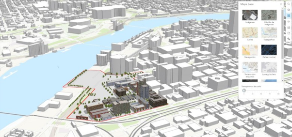
Combined, they form an interactive digital twin that enables authorities to evaluate not just what a building is, but how it interacts with its immediate urban ecosystem
Key Benefits for Digital Permitting
Automated Zoning and Code Compliance: Instead of manual cross-referencing between 2D paper drawings and statutory text, rule-based computational engines can ingest an open BIM file (e.g., IFC) and automatically check it against spatial GIS constraints (e.g., maximum allowable heights, dynamic setback limits, Floor Area Ratios).
Pre-emptive Risk & Environmental Assessment: Overlaying detailed 3D structural data onto geospatial hazard maps helps reviewers immediately identify vulnerability to flood paths, seismic faults, soil erosion, or microclimate impacts before construction begins.
Multi-Agency Interoperability: A shared spatial-BIM common data environment (CDE) allows fire safety, civil defense, urban planning, utility boards, and environmental regulators to review, annotate, and approve project stages synchronously.
Public Engagement and Trust: 3D model overlays on live city web maps make future developments legible to the public, fostering trust through visible compliance.
Shorter Timelines, Lower Overhead: Eliminating manual redlining and back-and-forth paper reviews shortens development cycles and sharply reduces discretionary administrative errors.
Navigating the Current Urban Challenge
In fast-growing emerging megacities, building permit offices have introduced online single-window portals, yet many systems still rely on static 2D PDF blueprints and manual verifications.
Common pain points continue to include:
Time-consuming manual checking of plans against evolving land-use master plans.
Siloed geospatial data that fails to reconcile planned structures with existing utility networks and drainage corridors.
Administrative bottlenecks caused by disjointed inter-agency reviews.
Transitioning to an integrated spatial e-permitting model enables municipal agencies to automatically validate submissions against local building codes, verify alignment with public transit corridors, reduce subjective gatekeeping, and build long-term disaster resilience into everyday approvals.
Global Precedents
Several jurisdictions have already proven the viability of integrated digital permitting:
Singapore: Pioneers automated code-checking through national digital submission platforms, validating digital building models against technical regulations.
Finland: Spearheads open-standard 3D municipal planning by integrating open IFC models directly with CityGML-based urban databases.
United Arab Emirates: Mandates open BIM workflows across high-density developments to optimize infrastructure integration and municipal compliance.
Implementation Challenges
Open Standards & Interoperability: Translating high-detail architectural BIM files (IFC) into geographic coordinate frameworks (CityGML, 3D Tiles) requires common semantic data standards.
Technical Capacity: Building municipal staff and local industry proficiency in spatial data schemas and automated model-checking software.
Statutory Frameworks: Updating building regulations to accept parametric 3D models as legally binding application documents.
Initial Capital Costs: Software infrastructure, data storage, and network capacity upgrades needed across municipal departments.
The Road Ahead
Modernizing construction permitting is best realized through a phased rollout:
Targeted Pilot Programs: Launch spatial validation pilots on commercial and high-density residential projects within core urban corridors where application volumes and design maturity are highest.
Regional Scaling: Expand mature workflows to secondary urban hubs experiencing rapid peripheral growth to avoid repeating legacy planning mistakes.
National Open Platforms: Consolidate isolated spatial layers into a standardized, web-based digital twin permitting framework open to all municipal jurisdictions.
By moving beyond disconnected 2D blueprints toward semantic 3D data integrated with live geographic context, cities can establish a faster, more accountable, and fundamentally safer built environment.
The future of construction permitting lies in this digital convergence. Bringing BIM and GIS together shifts regulatory review from a slow, manual hurdle into an intelligent, proactive safeguard for urban growth. Embracing this integrated approach is ultimately less about adopting new software tools and more about securing safer, more resilient, and well-orchestrated cities. As urban centers expand at breakneck speed, the question is no longer whether modern permitting authorities will integrate spatial and building data, but how quickly they can execute the transition to meet the demands of tomorrow.
Share this page via